Hiked February 4-5, 2012
Following our foray into camping at King Lake and Coopers Creek I was resolute in transitioning my outdoor experiences from camping to hiking and preferably where a car could not get into. I was still missing the Northern Territory experience, arguably one of the most special places on earth for enjoying the outdoors. I accepted Victoria was where I lived now and better get on with exploring it. My eldest daughter had turned 14 and I was keen share my love of the remote outdoors with her.
I dusted off the old pack, the type with the internal metal frame and heavy canvas material and my newer North Face Terra pack and determined we would find somewhere close to home to trial what hiking was like in Victoria.
I wanted to make sure I found an easy short walk my 14 year old would enjoy and hopefully develop a love of the great outdoors. Looking for a suitable place close to Melbourne’s South East, the Walk into History (2 hours from the city), just out the back of Powelltown seemed perfect.
Excited to have found a place and set a date, the challenge started to amass the gear necessary to make an overnight stay work. My small two pole A-Frame from my scouting days was long gone and it was time to acquaint myself with the new, thank goodness for the Internet. After much research I settled for a Black Wolf Mantis II.
The Mantis II is a light weight 2 person tent (~2.4kg) that packs neatly in the provided compression bag. It’s a simple two pole tent, with entrances on both sides, good size vestibules and at its peak has just enough room for me at 5’11 to sit up.
With old and new packs, my newly acquired tent, faithful old MSR Whisper lite, water, food, clothes and first aid kit we set off with great excitement and expectation.
The drive up through the forest to Powelltown is beautiful, scenic farm country intertwined with forest. The Walk into History show cases the significant impact and contribution logging has had on both the environment and the heritage of Victoria.
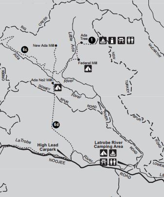
The walk starts on the East side of Powelltown and for the first 10km’s follows the creek and road that eventually leads through to Baw Baw, before veering left and into the thick temperate forest. Alternatively you can park the car near the Latrobe River and disappear into the forest on the Walk into History from there, we started from the river.
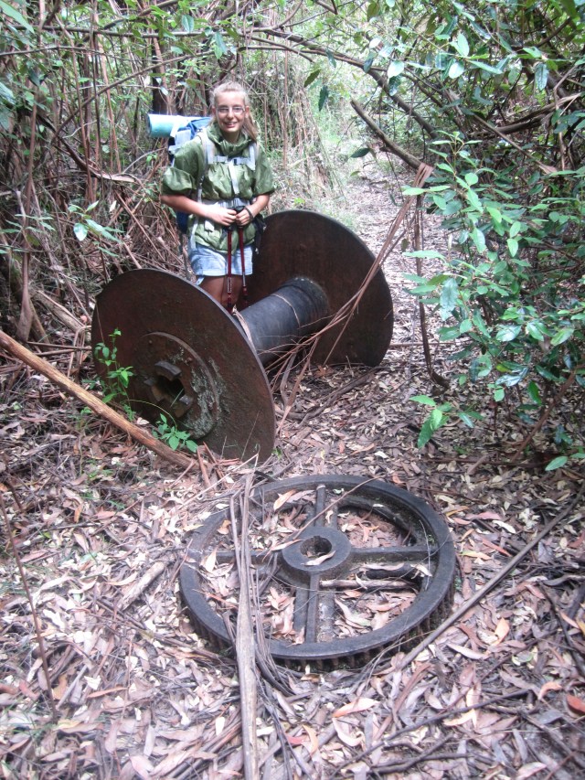
The walk starts easy enough, shortly after being engulfed by the ferns and moist forest is the LaTrobe River crossing. A cobble of logs and rusting pipe handles help you keep your balance as you tight rope walk over the river, easily done.

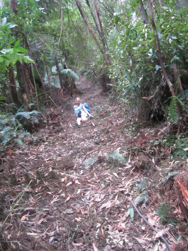
The track widens slightly and follows the tram route, now nothing but a raised flat trail that was used to get the old growth forest logs off the hill and down to the mill at Powelltown. The track quickly becomes a foot trap, with lots of fern branches and many other debris, little sign of use in a long time. After several more small creek crossings, the approach of the high lead incline is in sight, 400m elevation over 1.6 km, no switch backs.
The walk up is like a step master, steep with very few flats to catch your breath. That coupled with the warm summer weather, really gets you sweating. At about half way up we crossed the Dowey Spur road, a dirt track that divides the high line and gives a place for respite and my daughter to catch up, I’m the faster up the hills but she always beats me on the downs.
Low and behold I see someone making their way down and imagine my surprise when I recognise the walker as a colleague from one of my previous workplaces. We have a quick conversation and I discover the high lead is a favourite training destination for people brave enough to take on the Kokoda trail in Papua New Guinea and that is where he is shortly headed.
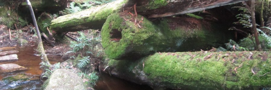
While no Kokoda, we rehydrate with Staminade an old favourite of mine to replace salts and lift electrolytes and get back on our way. The first signs the High Lead incline is coming to an end, is the remnant of the winch assembly and some well buried cable that was used to lower the logs down to the waiting tram.

The terrain flattens out and it’s less than a kilometre before you cross the Ada river, more like the width of a creek, but reasonably deep the water is beautifully clean and cold, and we’re overcome with the temptation to have our fill directly from the river.
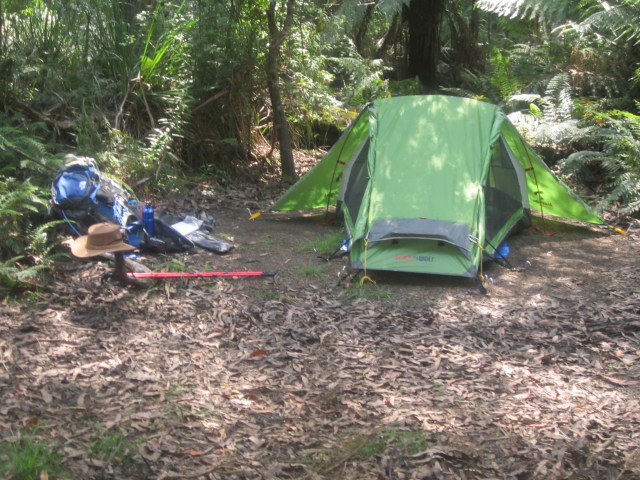
A few 100m’s and the track widens out into a flat open space, known as Ada No 2 Mill Site. The mill was destroyed in the 1939 bushfires and now buried in the forest are old relics of a bye gone era, but our focus is on finding a suitable spot to make camp and pitch the tent. We’re on our own, either this place is the best kept secret or we’re crazy to be out here.
We find a nice clear spot with little over hanging coverage and pitch the Mantis II, a simple peg to the ground setup, with waterproof fly, probably won’t need that tonight, but you never know in the forest. My daughters interested in making a fire and heads off to find wood, while I roll out the sleeping bags, no pillows or inflatable mattress, this will turn out to be the last time I camp like this.
Exploring the area we discover the river winds around behind us, but given it’s January it’s pretty dry. I’m keen to head back to the Ada River and cool off, but first we explore the track which continues north to a junction that leads to Federation Mill to the right and Starling Gap to the left. As an A to B route you can walk all the way through to east Warburton, we’re not doing that this trip.
Heading back to the river, we negotiate a bog, which was successfully skirted around walking to the junction, I put a foot on a log that looked safe, but it gives way, I lose my balance and sink in the bog, now I have a real reason to get into the river, clean up and cool off.
Back at camp, we’re in the twilight zone that Melbourne experiences in high summer, getting ready to prepare dinner, small bugs start to appear and before long it’s like a cloud, they seem to be attracted to the last rays of the setting sun escaping through the forest. Nothing gets them moving, they swarm us and sitting near the fire doesn’t help, making dinner is a long lost dream. We’re driven into the tent to escape the cloud and there we stay for the next two hours. Someone forgot to pack the cards, so little to do but wait.
With the last rays of the sun extinguished and the dark engulfing the light the bugs finally head off to bed and we’re left to enjoy the clear night sky, a late dinner, but who cares, time out here means nothing.
We warm ourselves in the last embers of the fire and head off to bed, listening to the sounds of the bush and the rummaging of our nocturnal friend the Wombat.
I toss and turn throughout the night, the younger me might have been able to sleep without a mattress and pillow, but the older one is having none of it, promising myself that my next purchase is a mattress and pillow.
The morning can’t come soon enough, the warming rays of the sun stretch out over our tent and I cannot believe the day is beginning already, I hide my head from the light and steal a little more time before getting up.
With the site cleared, we don our packs, I’m keen to make something more of this walk than just the return trip, so decide to explore Federal Mill (2.2km north east). Navigating the bog this time successfully, we make a right at the Junction and head off deep into the forest. The wind is picking up and it’s starting feel a bit eery, but we continue on any way. Soon we arrive at another river crossing, the old bridge is clearly visible but cannot be crossed, broken and covered in moss it makes for a great photo opportunity, capturing something of the hardship of life when this area was bustling with the sounds and activities of logging.


Over the creek we soon come to another clearing, Federal Mill 2, there are a few benches, an old photo of Mill life and a 4WD track entering the site. There is no one here, but signs that people were, not all that long ago.
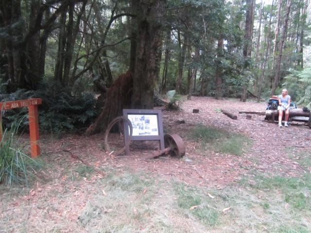
With the spirit of adventure alive in me, I’m keen to explore further and find the Ada Tree, the last of the surviving old growth forest that I’d read about in books, we find a sign that leads the way, the wind has picked right up now and I’m torn between exploring and reading the signs of an impending storm, my curiosity gets the better of me and we push on for the Ada Tree.
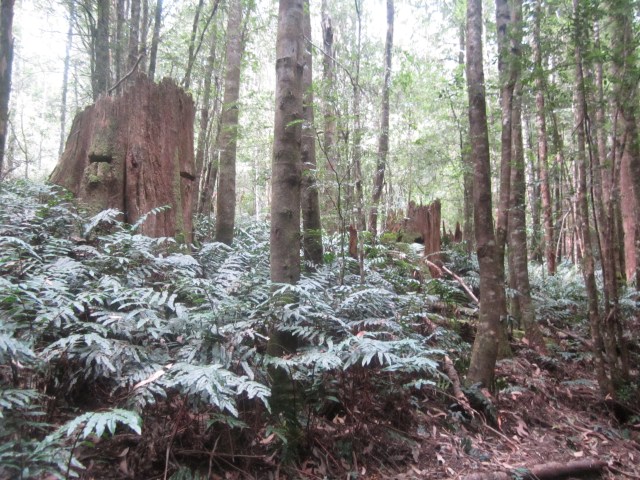
We follow a creek, Little Ada River, trickling along and overgrown with ferns, the sort of environment that you expect to see elves popping up in. After what felt like an eternity large tree trunks come into view, well-aged and moss encrusted with signs of their felling in the gouges that once supported the planks the axemen would have stood on.
Continuing to walk through what feels like a tree cemetery, felled trees with trunks as tombstones, bleached in the sun, a boardwalk appears in the distance and it signals we’ve found the Ada Tree. Surprisingly after seeing no one all day we’ve found people. The tree looms large, its trunk bridled by a board walk, so all can enjoy it’s majesty without disturbing the ground around. While not the size of the Sequoia’s in California, it’s impressive none the less, particularly given there is so little old growth forest left.
The Ada tree is believed to be 300 years old, a seedling in 1715, many years before Captain Cook first laid eyes on Australia in 1770. At 75m in height, its approximate weight is 225 tonnes and its girth is 15m around chest height. The tree is located in a little niche in the rainforest which has protected it from fire and it’s believed the timber workers thought it was full of white ants and left it alone. The tree and surrounding forest is part of the Ada Tall Trees Reserve and is now protected from logging.

With the wind now harassing the trees and roaring, it’s time to retrace our steps and get out of here.
Luke records in the Book of Act’s that when the disciples were in the upper room waiting for the Holy Spirit who Jesus had promised, it was like a rushing wind and tongues of fire were on their heads. If the rushing wind was anything like what we experienced, you’d really sit up and pay attention to God’s power and what he was doing at the time, it reminds me the bible’s no fairy tale, but a gritty account of His story.
It’s surprising how quickly a trail walked can be exited, I guess it’s predictable and going downhill helps. My daughter beats me down, my knees start giving out with every jolt of the relentless incline and I’m relieved to be back at the tram line.
We exit the forest and make a run for the car as the rain starts coming down. What a great experience The Walk into History is, we’ve affectionately renamed it the Walk into Hell after the hell it was to walk the High Lead incline.
The good news is my daughter has enjoyed the adventure and I’m hopeful we’ll do this again, not this walk but another as we continue to explore the amazing places Victoria has to offer.
Park Information
Distance from Melbourne – ~80km or 1.5 hrs, closet town is Powelltown.
Park Type – State Forest, fireplaces and pets (with conditions) allowed.
Camping – There are two main campgrounds, Latrobe River Camping Area and Starlings Gap with pit toilets and picnic tables. There is no booking, first in best dressed. Additionally you can pitch up at Ada No 2 Mill (walk in only) and Federation Mill sites, however there are no facilities.
Water source – There is no potable water however the Ada river had good flow when we were there (February), recommend you bring enough water for your stay and if you do need to drink the river water boil it first.
Attractions – Swimming, exploring forestry relics and the Ada Tree.
Reference – DSE Yarra State Forest
