We’re stepping up our hiking experience, something bigger taller and longer than we’ve done before is in our future. Mt Feathertop has been in the news thanks to a politician who got lost up there, it got me interested in this place. I knew it was our second highest mountain in Victoria but that was about it.
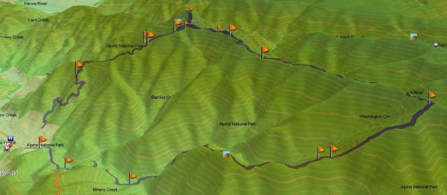
Deciding it was the place for us, I read a number of blogs and planned out a 33km route over three days that would take us up the Bon Accord Spur, along the Razor Back and down Bungalow Spur with two nights on the mountain.
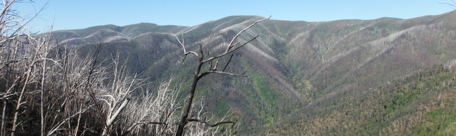
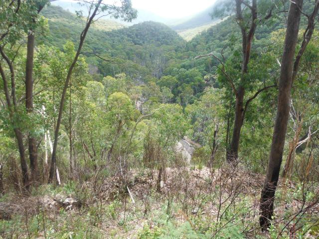
Mount Feathertop is the second-highest mountain in Victoria and part of the Australian Alps. It rises to 1,922 metres and is usually in snow from June to September. Most Victorian mountains have domed peaks like Mt Bogong, however Mount Feathertop has a steep summit slope rising sharply on all sides. Carved into the steep eastern face, Avalanche and Hell Fire gullies graphically describe its ruggedness making it an attractive climb.
A sizable snow drift forms along the summit ridge in winter, which has claimed a number of lives on collapsing. The drift and spring snow remaining in the gullies give the appearance of feathers – hence the name “Feathertop”.
Dr Ferdinand von Mueller was the first non-indigenous person to climb Mount Feathertop in 1889. A track from Harrietville was cut in 1906 close to the current route of the Bungalow Spur track and a rough shelter built near a spring on a flat area below the tree line. All the huts on the mountain at one time or another have been lost to fire. There only two huts on the mountain remaining are Federation Hut which was rebuilt in 2005 and Melbourne University Mountaineering Club’s Geodesic Dome, a whole other story you can google for yourself.
This would not only be the longest walk it would also be the longest drive at 4 hours (from Melbourne) to the trail head. We had chosen to do the reverse walk to most people and trail head was difficult to find, hidden down a non-descript dirt road that the 2wd drive found challenging to get into.
All that marked the trail head was a sign and a place to enter your trip intention and then it was onto the track to be absorbed by the scrubby bush and the sound of birds. I wasn’t even sure we were on the right trail to begin with. With few marking and a challenge getting my GPS to triangulate we were not off to a good start. This would be just the start of events that would challenge our mettle over the next three days.
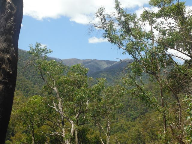
The track meandered through the bush on a gentle incline and I was starting to think we were making good progress, while at the same time looking to the top of the razor back in the distance thinking to myself we are going to have to make that elevation up at some point.
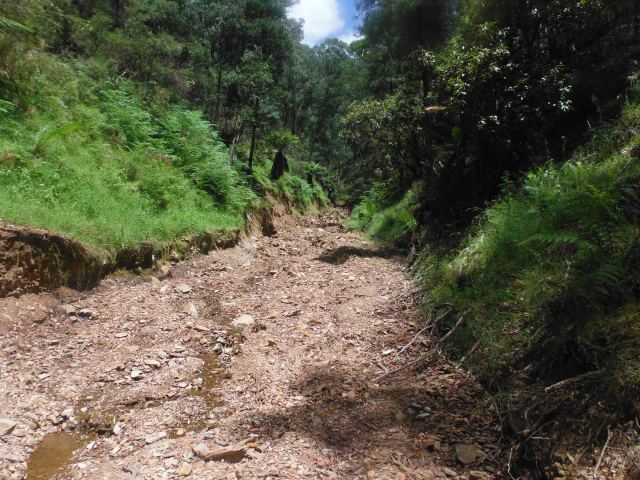
There had been heavy rain the area and what were little gullies had become small canyons, where rock and tree had rumbled together scouring the bank as the water surged through. In some places track markers had been swept away. It was not uncommon to step into the gully and pause to identify where the track commenced on the other side.
We could hear the sound of running water, we must be getting close to the river crossing we had seen marked on the map. Again the rains had altered the track and forced us to skirt the hillside now with the river bubbling and frothing below us. With little to hold to we balanced our way back on to the track proper. Thankfully there is a bridge to cross the river, I consoled myself.
Approaching the river crossing I was relieved to find the bridge intact, but something wasn’t right, was my mind playing tricks on the me? I was hot, but not delirious! Isn’t the water supposed to flow under the bridge not in front of it? I did a double take and sure enough the bridge was intact but the river had completely changed course and was now running in front of the bridge instead of under it, what the heck is going on here!

Slightly downstream was a rocky bank and hot and flustered after less than 5km of walking we decided to take the packs off, eat, refresh our faces in the crystal clear mountain water and give thought to the crossing.


We could walk across, but we’d get wet and it was running pretty fast, I didn’t want to slip and lose the packs. Claire finds a fallen tree a little further downstream, it’s safe to cross I hear her yell, yeah right I think to myself, not liking the idea of balancing a pack while crossing something not much wider than a balance beam.
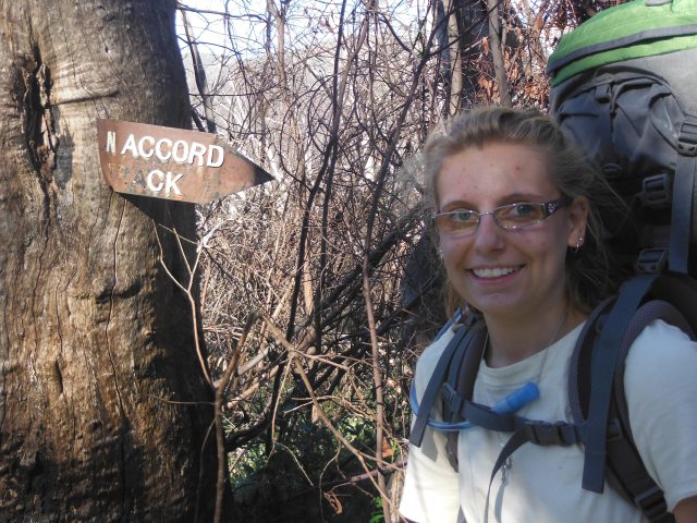
Claire moves across with easy, must be the gymnastics practice I tell myself. Now it’s my turn and with arms out and a bit of wavering I clumsily make it across without falling, even time to stop for a photo.

Relieved and rejuvenated we follow the track across what was the river bed, skipping over a few puddle and re-joining as we hit the Bon Accord spur proper and hit it we did. Like a step master the spur climbs aggressively upwards and in the heat of the midday summer sun we sweat like a tap leaking water, surely this cannot go on too much further but it does.
One foot in front of the other we continue to push ever upwards for what seem like an eternity. I’m alert for snakes, it’s warm and this is perfect country for some of our best known venomous friends to be out and about.
I stop suddenly hearing something. Looking around I can’t see anything, then realising I’m hearing the sound of my heart beating out of my chest with excursion, it’s time for a rest.


At the top of the first ridge the spur flattens out as we cross the saddle and like all saddles it’s a wind tunnel, amazing how quickly our bodies move from hot to cold. Our sweat has made us like evaporative coolers and while we enjoy the respite we work to get across the saddle before we cool down too much.
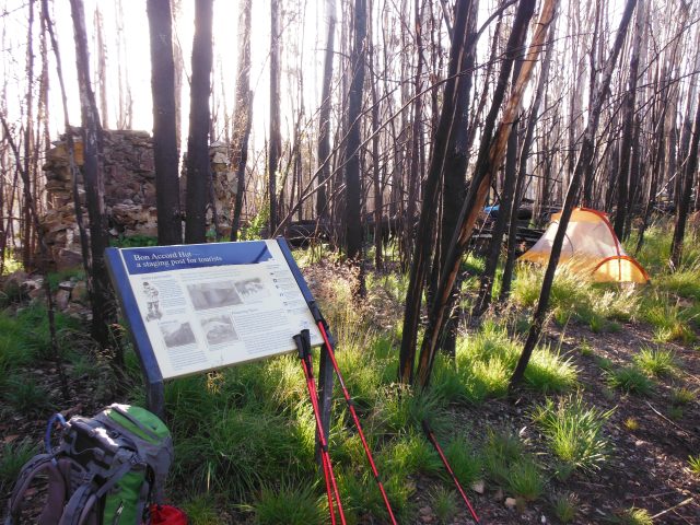
A further ridge presents in front of us and I’m sure at the top of this is the small saddle we’ll call home for the night, the location of the old ruins of a long lost cattleman’s hut. Without further event we make it to our first nights’ accommodation and a beautiful view of the sun arcing towards the horizon.
The Bon Accord Spur was the route taken by walkers, horse riders and pack horses to Mt Hotham before the Great Alpine Road was built. The Bon Accord Hut has had a number of iterations. First built in the 1920’s as a graziers dwelling when cattle were kept in the high plains before becoming an overnight accommodation for pioneering skiers. Now the crumbling chimney is all that remains to remind us of this pioneer past in an unforgiving terrain.
The signs of fire are ever present and it’s not been long since fire ravaged the middle elevations of the spur, the evidence being apparent since the last saddle. There was little greenery to pitch on, no protection from the west wind and no water as we thought there might be. All up an ideal place to stay the night.
We like to look at these predicaments as a fun challenge to solve and the first one is where to pitch the tent. The only place where the ground is flat enough and there are a few stalks of grass to protect the bottom is in the wind, so we’ll have to solve for the wind problem given landscape pitch is not negotiable.
With the test clear we set about solving for the wind. Really we just need to block about 3 feet in height that will keep the wind off the lower extremities of the tent and more importantly us when we’re lying down. Claire notices that in the burnt and charred bush of the saddle, there are a lot of tree branches and trunks down and sets to work gathering a few nearby to build a wind break, great work.

With camp made we spend some time to understand what life must have been like here in a time long past. Exploring around the old fire place, we find remnants of glass bottles, steel spikes, like ghost they point to the past. With your eyes shut you can imagine them point you back to the past, a peak behind a curtain to the very personal challenges and success of the many people who have been before us, if only the old chimney could talk.
Dinner is next on the to do list and I’ve brought my trust Whipserlite with me. The great thing about these is that they are field maintainable, not that I have had to do that very often.
The wind has continued to steadily push its way across the saddle and even as the sunset starts to think about setting there is no let-up. The remains of the old fireplaces chimney make for a good wind break and this will be our dining room for the night.
I fire up the Whisperlite but it just doesn’t seem to have the heat it normally does and it’s not long before it flames out. I check the fuel bottle no problem there, good pressure and plenty fuel. I momentarily wonder whether the air is too thin but quickly dismiss the idea. Our highest point in a Australia is 2228m, a mere hill compared to other countries so oxygen content is the problem. It likely the jet has carbonded up.
I set about pulling the stove apart in the dimming light supplementing with my head lamp. Fumbling I drop the jet amongst the rubble of the chimney, not a good start to dinner. After some searching I’m thankful to find it and with repairs completed we get on with cooking.
The sunsets between the charred trees standing like grave stones in an otherwise bear landscape, with a just a hint greenery that life will flourish here again. It’s a great photo opportunity something that Claire and I share as an interest on our hikes.

As I reflect on the climb for the day it was steeper and took more out of us than we thought including our water supplies. There is no visible water on the saddle and no sign of a spring. We still have two days to ago, the weather is hotter than predicted and there is no guarantee that the water tank at Federation Hut, a day’s walk away will be full.
To make matters worse I discover after dinner that the valve on my water bladder was not properly shut and I’ve lost about a quarter of a litre watering the parched ground. I didn’t pick it up until this hike but my nightly routine, is all always to have a good drink of water and go to bed well hydrated.
I sacrificed the routine for the night, deciding water would be more important during the day than overnight. I tossed and turned for a while, my mind became fixated on water, it was all I could think about, I craved it and there was a sense I’d do almost anything for a drink.
It got me thinking about Jesus, words. He said to the Samaritan woman at the well, anyone who drinks of this water (in the well) will thirst again but anyone who drinks of the I give will never thirst. The water I give will be like an artesian spring within, gushing fountains of the endless life.
When our circumstances are good, things are going our way, we’re happy to drink from the well, it supplies faithfully. But when circumstances are not to our liking, things aren’t going well, it’s like the well has dried up. It’s in these moments we need Jesus the most to provide us the water that never runs out, his love, mercy and grace in our situation. No surprise how fixated people become in filling the hole in their life when their circumstantial well runs dry. I pray we’ll have enough water for the trip.
Hiked January 6, 2014
Park Information
Distance from Melbourne – 350km or 4 hrs, closest town is Harrietville.
Park Type – National Park, fireplaces, pets and firearms are prohibited.
Camping – Dispersed bush camping is permitted in most of the Alpine National Park. The park is a fuel stove only area; therefore no solid fuel fires are permitted. Try and camp in already made sites to protect the fragile alpine environment from further damage. There are no facilities in the Mt Feathertop area other than at Federation Hut, which is available for emergency accommodation, pit toilets are also available at this location.
Water source – There is no potable water in the park. However water can be sourced at the crossing of the Ovens River East Branch on the Bon Accord Spur track, Federation Hut providing the water tank is not empty and from a spring near the old Bungalow Hut site on the Bungalo Spur track.. We did not find any water sources on the upper reaches of the Bon Accord Spur or the Razor Back. No water source is guaranteed year round. All of the above mentioned sources were available to us (January), recommend you bring enough water for your stay and if you do need to drink river or tank water boil it or in some other way treat it first.
Attractions – Landscape views, summits, exploring, peace and quiet
Reference – Parks Victoria – Alpine National Park

Pingback: Day 2 Mt Feathertop, we’re on top of the world | Hiking Faith