With confidence built after climbing the exposed rock face on the canyon track of Sugar loaf a week prior, we decided it was time to strap on the boots and break the hiking drought that hit in 2015 with my daughter completing year 12.
It was the first week back at work. The weather had been very hot over the Christmas holiday and we had not had the chance to hike over that period. Now the weather was favourable and work was slow so I decided to take the end of the week off and go hiking.
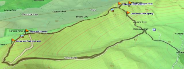
The cathedral range is a spectacular seven kilometre ridge of sharply upturned sedimentary rock in the Acheron valley, about 130km or 2.5 hours’ drive from Melbourne. There are a variety of walking tracks ranging in difficulty from easy to challenging that offer the opportunity to explore the park’s main features and climb the peaks and enjoy the amazing views. There are two “walk-in” camp sites, Ned’s Gully near Little River and Farmyard found on top of the range as well as one “drive-in” site, Cooks Mill, also near Little River. Walking, rock climbing, bird watching and fishing are all popular activities that can be enjoyed in the park.
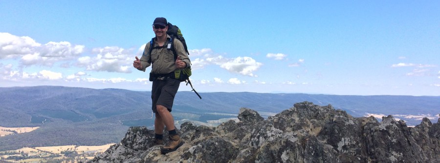
Our packs are strapped on, I’m carrying 15kg and already I’m questioning what I was thinking hiking this up the canyon track, over Sugarloaf Peak (902m elevation) before descending along the sharply upturned rock razor back that runs from the northern end of Sugarloaf to South Jawbone Peak and Farmyard.
The walk starts as a dirt track and quickly to turns to rocky outcrops climbing up to the beginning of the exposed rock section known as the canyon. It’s a narrow incline boarded by the base rock on one side and an outcropping rock on the other, it’s not much of a canyon but the exposed ledge walk above makes up for it.
I’m confident getting up this after last week’s success, although a little concerned lugging a heavy pack. Up the first part easy enough, I come to the exposed rock face, it’s only a few metres of steep ledge climbing, however a lapse in concentration or a slip is all that would be needed to do damage.
With my daughter already up and waiting, I start the climb. Wedging my foot into a split in the rock and getting a good hand hold on another, I haul myself up, but the weight on my back wears on my arms and I’m unable to make the move smoothly to a new foothold. I’m half way up and feeling the strain laying on the rock best I can, hoping I don’t slip.


Battling a crashing wave of fear my thoughts turn to the pain of broken bones I experienced riding bikes as a teenager. I grip the rock and hold tight, listening to my breathing to calm down and reminding myself I don’t have a spirit of fear but of a sound mind.
Calmed, I look down and see where my foot needs to return to and gingerly start releasing my grip, sliding slowly back down the rock to my former position. I reassess the situation and fight back thoughts that hike is over before it’s begun. I see a slightly different approach to getting up the exposed ledge and take it, success I’m past the hardest point on the climb to the peak.


The remainder of the trail to the summit is fairly simple, there are two further rock climbs but they are relatively simple and not exposed like the first.
The temperature has climbed as well and sweat has been pouring off my nose like a tap, I’m gulping for air to fill my lungs and oxygenate my muscles. It like we are at 4000m, but it’s only 900. A slight breeze picks up out of the south west and as it hits us we are instantly refreshed, taking a break before the last obstacle to the top.
One more little rock climb between two rocks that narrow at the start and widen out at the end and we’ll be on the peak. It’s usually an easy climb but I get stuck with the pack and what should be simple becomes complicated. I lock my feet against the rock and chimney climb while doing the splits to get out of the predicament.
Punching the air I savour the experience of the top and we take a well-earned rest letting the wind cool our overheated bodies as we take in the vistas across the Acheron valley and back toward Little River. Sugarloaf peak is like Bourke Street with people ahead of us and behind. There’s a large group of 18 teenagers on top and we stay a while and have a chat. They are going in the same direction as us but to my relief they’re not camping overnight, it’s a straight through trip for them.


Feeling energised, in good shape and mildly confident, bar a few scrapes and a ripped shirt where it caught the rock as I slid, we make our way towards the Razorback and for us what is the unknown.
The Razorback is obscured from view, we’re still too high and it looks like we’ll be descending a sheer a drop, I ask some others who have just come what it’s like and they tell me it’s hard. It’s not what I wanted to hear and I maintain a level of in trepidation regarding how we get off this peak. One foot in front of the other is the answer.
I think to myself life is often like this, we can’t see far enough ahead, the detail just isn’t clear and sometimes the challenge in front of us seems in surmountable but faith is putting one foot in front of the other and believing God has you. For me it’s similar to climbing, when you look out at what you have to achieve some of the ascents and descents look impossible. When you get on the trail though, one foot in front the other you find a way and some of the things you thought you were going to have to go over you go around. This is why we need only the faith of a mustard seed because we only need enough faith to take another step and then another and then another and before you know it looking back you beat the mountain that before seemed impassable.
The path winds around the rocks on top of the peak, but don’t fooled by the description it’s pretty flat with lots of safe area to stand if heights and exposed ledges are not your thing. Descending, the track winds around to the west avoiding the sheer rock faces of the east side, with just a few ledge walks, but nothing terribly exposed.
At a point you lose yourself in among the rock scrambling neither being able to see Sugarloaf Peak or the Razorback proper. There’s a strange sort of security, you come to forget you are still on a high exposed rock ledge.


That feeling fades quickly with a short but steep descent, I sit down to shimmy onto the lower rocks, but my packs keeps wanting to eject me off the mountain all together. Reluctantly I remove the pack, but now I notice how narrow the ledge is and the drop below. There is an alternative shorter route but at times it’s fully exposed to the east face and its sheer drops. Seeing lots of hand holds I take the slightly exposed route, this is the last difficult section.

On the Razorback proper now we maintain concentration even though the walking is less technical, this would be a great place to roll an ankle by relaxing our attention and believe the toughest part is behind us.
The track continues for another 2 or so kilometres of rock razor back interspersed with sections of flat walking. With the rocks well warmed small lizards make their way out of little caverns in the rock to warm themselves. Watch out for snakes, we didn’t see any but other walkers did.
On approach to Farmyard the track veers to the west and starts a steady descent off the Razorback. The trail narrows as the vegetation continue to encroach forming a tunnel of mid heights trees to walk under, no sooner are you through this section and landscape flattens into a shallow bowl, the trees retreating back to reveal the camp site.


Farmyard got its name after campers heard the Lyrebirds mimicking the sounds of farm animals they had heard in the Acheron valley.
Lyrebirds are an Australian species of ground bird that spend most of their time turning over the leaf litter and top soil looking for their favourite food, cockroaches, beetles and earwigs. Lyrebirds are most notable for their amazing ability to mimic natural and artificial sounds from their environment. My daughter has heard these birds imitate a Chicken, Kookaburra, Cockatoo and Currawong amongst others. In addition to their incredible mimicking ability is the striking beauty of the male bird’s huge intricately painted tail plumage when it is fanned out in display.
Lyrebirds are long lived up to 30 years, likewise they have long breeding cycles and start later in life. Males defend territories that may contain the breeding territories of up to eight females. Male Lyrebirds call mostly during winter, when they sing and dance in courtship to attract a mate of which they have several. The female lays a single egg, she is the sole parent who incubates it over 50 days until it hatches and then is the sole carer of the chick.
The camp ground has no facilities, including water. The start of the jaw bone creek is nearby however this is rain dependent and should not be relied on.
The perimeter of camp ground is line with trees, otherwise bare and in most areas devoid of grass. Feeling dehydrated and overheated after a 4 hour walk that was planned to take us three we find a shady, drop the packs and take a rest.


While Claire sleeps I get restless and go and explore the camp ground, finding the start of the Jawbone creek, but to my disappointment it is dry, under the debris choking the creek the dirt is moist but there is no drinkable water, unless you are desperate to dig and filter. I go in search of the fable spring I’ve heard about but find no sign of it.
I discover farmyard is shaped like an hourglass with a small trail in between the two large sites. The second site is steeper and concludes at the trail intersection of Cathedral Peak, North Jawbone Peak and Jaw Bone Creek track which takes you back down to a car park, a short distance away from Cooks Mill. A great exit point for a day walk up Sugarloaf Peak, along the Razorback and down again.
I’ve spotted to Lyrebirds by this time, one with the stunning plumage I wrote about earlier but both were busy foraging and unfortunately didn’t get to hear them imitating any farm animals.
Claire is still a sleep and I have given into my exhaustion feeling even more dehydrated fighting a headache a good sign I have not drunk enough. In extreme cases, dehydration is accompanied by rapid breathing and heart rate, very dry mouth, sunken eyes and little or no urination, in these circumstances you need to seek medical aid immediately. Concerned we didn’t being enough water for the two days, we still needed to walk the 3.5km Cerberus road back to the car, I rest and hold off on a drink until dinner time.
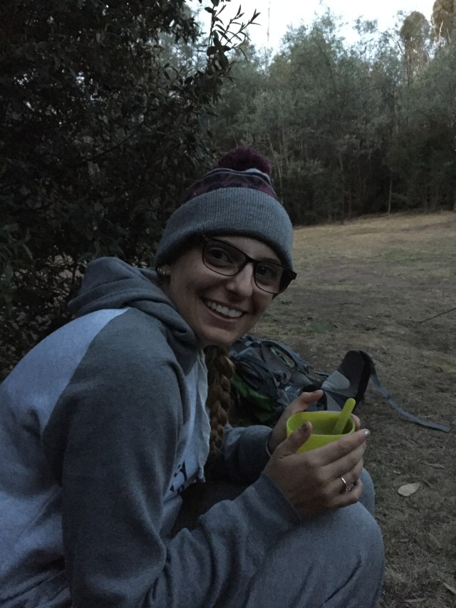
With the sun starting its retreat for the horizon and shadows engulfing the camp ground the temperature starts to drop. Picking up our energy levels, we make camp pitching our faithful Mira II and start on dinner.
Food is what I need and I pick up immediately for eating and drinking. Earlier in the day we met two guys who were also camping at Farmyard, I discover one of them, Richard is a keen photographer and what’s more he’s into astrophotography, an interest of mine. It’s his second night out catching the night sky on his camera, I agree to meet him later on South Jawbone Peak for look at the stars.
With dinner finished and energy levels replenished we make the short 10m minute journey up to the top of South Jawbone Peak for sunset, it’s an easy walk with a little rock scramble at the end, nothing compared to what we went through on the razor back
The wind is howling and it’s getting quiet cold in sitting on the exposed peak, thank fully I’ve brought along my new Outdoor Research Transcendent down jacket and Rab Xiom water proof shell, both working to keep me warm while not adding to much weight.
The sunsets into a cloud bank and we get some great shots with the gnarled and burnt trees in the foreground, much of the surrounding area was razed during the Black Saturday fires of 2009 and on the surround ridges is the eerie reminder of that horrific day, many trees now dead and but standing like tombstones in a grave yard.


I joined a volunteer crew working with the Australian Army and other organisations to bring in much needed supplies for people and animals as well as help in the clean-up in the days after. The aftermath was nothing like I had ever seen in my life, the devastation was palpable and for months after I was affected by peoples loss even through it was not mine and nor did I know anyone personally.
Back at camp we boiled the billy and had our usual hot Milo and chocolate bar. Given we’re in the southern summer twilight hung around till 10:30pm, obscuring a full few of night sky till then.
With the sky now black as pitch and clear of clouds I say good night to Claire and make the short trip back up South Jawbone Peak to join Richard for some astrophotography. Richard was well set up and had started taking interval shots of the night sky, the objective to capture star trails around the south celestial pole. The wind was howling and I was concerned a gust would blow his expensive camera equipment over the edge, acutely aware we were sitting on the precipice of a sheer drop. Thankfully no such incident happened and Richard was rewarded with some impressive shots for his efforts.

In high summer the Milky Way runs directly overhead the ridge and in the jet black of a country night with no artificial light to interfere, the stars feel close enough that you could you reach out and touch them.

Orions belt seen upside down in the Southern Hemisphere, also known as the saucepan and amongst Claire’s friends the “Shopping Trolley” sits high in the sky as the Southern Cross rises. It’s a moonless night and even the dust clouds are visible as we are wowed by shooting stars and watch Satellites race each other across the skies.

Bed was beckoning, the wind persisted throughout the night and into the early hours of the morning, but snug in my down sleeping bag with pillow and mattress it didn’t bother me too much.
Waking to the sun breaking over tent, the wind had died completely and there was an eerie calm, looking up I could see the dew had been heavy overnight, one scrape of the tent against the fly and we’d be wet. With only a few hours of the hike left I took the opportunity to climb North Jawbone Peak in the still and cool of the morning.
From Farmyard the trail climbs steadily back up the ridge as if your were going to Cathedral Peak, following the now narrow channel of Jawbone creek, which at this point looking nothing more than a depression in the ground. Shortly I find myself at the top of a little saddle, the area is quite flat and would make a great camp site, as some have already discovered and experienced. It reminds that we should always scout the area before making camp, the area here is flatter and grassier than Farmyard.


Veering to the right and continuing the journey the saddle runs through a thicket of bush and then empties out into another open area with views back to Sugarloaf Peak and forward to the ranges in the north. It’s covered in low heath like shrub, no good for camping. The climb begins not far from here and it’s a steep rock scramble to the top, which is quite treed and the view is rather disappointing. The peak is flat and there are no exposed slopes at this point.
I spot the trail leading down the other side and follow, rewarded with spectacular views right the way along the east side of the range and again taken back by the sheer rock ledge which makes up the distinct North Jawbone Peak as seen from the road.

The wildlife must still be in bed, there has been no signs of the Lyre birds or the wallabies we’d seen yesterday. With camp packed up, we’re the last to leave. No fire to put out here, it’s hot and dry and thankfully all of us staying at Farmyard decided silently we wouldn’t have a camp fire.
The sun is already high in the sky as we make our descent down the Jawbone Creek Track. Thankfully the start is not too steep and in shade, but this quickly changes and the experience is more like the 1000 steps, a memorial trail in Upper Ferntree Gully to the solider, many of whom lost their lives on the Kokoda trail, a theatre of war in the Pacific during World War 2.
About a third of the way down the trail flattens for a short period as it crosses Jawbone Creek, there is a faint hint of moisture on the rock and a lot of moss, I’m guessing this the fabled spring people have written about. Today though it’s still too dry to get any meaningful water, but I can see it has potential even when the creek would have stopped running.


The remainder of the trail is best done at a jogging pace, it’s less impact on the knees and ankles, we just have to be careful we don’t get going too fast. 20 minutes later and we are at the bottom of the trail at the lowest point, Maclennans Gully, its beautifully forested in ferns and cool, even though the creek below is not running.
While our pack are bit lighter we are both still carrying around 10kg and we have a 3.5km walk along the exposed Cerberus road which relentlessly climbs to the top of Sugarloaf Saddle and our car. The thought of the walk convinces us to hide our packs amongst the ferns and pick them up on the way back.
The Cerberus road is dry and hot and the constant incline takes its toll on my body, with 1.5 litres of water together and more at the car, I break the drought and drink as much as I need on the way, taking regular breaks to rest my burning legs, 50 minutes later the car is insight and our rock climbing, camping odyssey is coming to an end.


Back at Cooks Mills I can’t resist a quick dip in Little River, my feet go numb seconds after entering but it’s so refreshing I take the plunge and wash of the days of sweat, sunscreen and dust. What a great feeling to finish a hike in a refreshing mountain river.

Park Information
Distance from Melbourne – ~130 km or 2.5 hrs, closet town is Buxton.
Park Type – State Forest, fires are permitted in designated fireplaces, collecting firewood is prohibited.
Camping – There are three camp grounds throughout the park and a day area at Sugarloaf Saddle, with pit toilets and an expansive shelter as well as non drinkable water if the tank is full.
Neds Gully campground is a walk-in site just off Little River, it’s a nice grassy site that backs on to the range with pit toilets at the car park.
Farmyard campground is located between North and South Jawbone Peaks on the ridge. It’s walk in only and can be access from the ridge tracks either from Sugarloaf or Cathedral Peak. Alternatively it can be reached via the Jawbone Creek track, the easiest and most direct route.
Cooks Mill. This is the largest of the sites and is drive in, set by Little River it’s ideal for families wanting to spend time by the water and is only a short walk from the start of Jawbone Creek track for the more adventurous. The sites are reasonably non-descript with centrally located pit toilets.
Water source – Little River runs close by Ned’s Gully and Cook Mill campgrounds. You should bring sufficient drinking and use river water for non-drinking activities. Should you need to drink the river water ensure it is appropriately treated.
Farmyard has no permanent source of water and Jawbone creek cannot be relied on. You need to ensure all water you require is brought in with you. After heavy rains there is a spring from the rock about a two thirds of the way up the Jawbone Creek track that may provide sufficient water.
Attractions – Landscape views, rock climbing, Peaks, exploring, wildlife, peace and quiet
Reference – Parks Victoria – Cathedral Range State Park

Fantastic read. Well done
Thanks Anthony, glad you enjoyed it
Sounds like a fab hike. I make it to Melbourne once in a while and would love to have a go at that – but it sounds like the type of hike you shouldn’t do single and it’s not too likely I’d have someone along who’d like to join…
Thanks for reading if you are good with heights you should be fine I have seen a lot of solo walkers go to the peak and back. If you are here in summer there is a good chance of frequent traffic on the route