
Day 1 I wrote about the journey from Telegraph Saddle to Roaring Meg creek, you can read about it here, Wilsons Prom, a bucket list destination .
Day 2 I wrote about our experiencing the lighthouse and walking to Little Waterloo Bay, you can read about it here, Wilsons Prom, lighting up history
Day 3 I wrote about the view from Kersop’s peak and our rest day at Refuge Cove, you can read about it here, Wilsons Prom, Refuge Cove or was that party cove
The final day of the walk had arrived, it was tinged with sadness and relief . Although we had running water and been able stay reasonably clean, you could feel the sand and salt. Add to this a restless night sleep from a sore body and a hot shower and comfy bed was calling to me. We’re heading for our final coastal stop Sealers Cove. I’ve heard and read lot about it, it has a sort of legendary status and I’m curious to experience this place and see if the labels are justified.
I start the day with a walk along the beach, contemplating a morning swim as I wander down the inlet to the coves foreshore. No swimming today, there are jellies, beautiful patterned but I suspect will still sting! Packing up camp takes priority instead.


The walk from refuge to sealers cross small beach. The sand is a yellowy orange clour and on closer inspection is basically completely broken down granite, not quite peddly but not fine grained either, granitic sand is how I would best describe. The remainder of the walk is uneventful, effectively skirting the coastal end of the Wilson Range. There are a few great viewing spot but otherwise a lot of bush walking, which for us was hot given the almost completely still conditions. Sealers Cove came into view earlier than we expected leading us to believe we were pretty much there but the distance from the headland is deceiving. We get a bit disillusioned as the walk goes much longer than expected. Soon we’re rewarded with beautiful vistas as the beach comes into focus, stretching like a crescent, with mountains and their tight foliage bowing down to the coast. It reminded me of Cape Tribulation in far North Queensland, where the forest literally blends into the beach.


When George Bass first laid eyes on Sealers Cove he was taken aback by the 1000’s of fur seals and the plentiful freshwater and wood at hand to boil down blubber, setting the coves destiny in its name. Sealing was soon underway and it was such a lucrative business one ship alone over an 18 month took 28,282 skins. By 1840 the great sea elephants had disappeared entirely from Bass Strait and seal numbers had dropped to about 100 spelling the end . Whaling stations were estbalished but the competition from deep sea whaling ships ensured it is was a short lived proposition.
By 1854 timber mills were operating and it had become the main industry. I’m told there are still some remenants of the era with tramlines and parts of the jetty still visible if you look for them, we didn’t find them. In 1898 the Prom was set aside as a park, however Sealers Cove was exlcuded due to a reinvigotrated timber milling which finally ended in 1906 following a bush fire that destroyed the settlement.
Sealers Cove has the feeling of being in a crater of an ancient volcano, partially sunk, bound on both side by high mountains, clouds dripping like honeydew, tickling the tops of the trees as it teases it way to the ocean but doesn’t touch it. After a quick scout of the campsite, which has a more undulating terrain, interrupted by stands of trees and boulders, creating quiet private little pockets, we head for the beach.

I can see why people would book here and not Refuge Cove. The beach is measured in kilometres and even with a full campground there is ample room for private space. The imposing mountains continue to capture my gaze as does a bit of drift wood which sets a beautiful foreground object in an amazing landscape. I decided to swim here too, no surprise, the water feels warmer and is clear. It’s low tide which is a good things as we’ve got to cross Sealers Creek, but it also means that its a long way offshore to get into deep water. Once out in the sea I look back to a beautiful panorama of beach and dipping mountains.


We timed our trip to be several hours (3) after high tide. This make the Sealers creek crossing much easier, really no more than calf deep. I can see why Parks warn about crossing near the high tide. You’d likely have a chest deep traverse with packs held high above your head. Calire is focused on getting home and chooses not to swim but also doesn’t want to take her boots off to cross the creek, so I lug the packs across and carry her over, what else are dads for?


Putting my boots on and getting ready for the final 10 km walk out, I feel something pricking against my toes, it’s the same feeling I felt on the way of out of Refuge Cove and scrunched up my toes to move whatever it was. Believing it was grass seeds I flipped the boot off ready to tussle with these evil little things that knit their way into your sock and to my surprise a hairy caterpillar is jettisoned onto the sand, well I wasn’t expecting that! I don’t know what type it was I’m just glad its out and we each other any harm.
The walk out of the Sealers starts off easy enough with a kilometre or so of board walk over the flood plain of the Mt Ramsay and Wilson range. Carrying on the Far North Queensland theme it feels and at times looks like a tropical forest and turning to Claire I comment that I’d expect to see a cassowary make an appearance any time now. The boardwalk lulls you into a false sense of security as does the convoy of people also making their way out. Little kids which I’ve come to learn have more resilience than all of us and some American guys so passionate about scuba diving they’ve wheeled in air tanks on purpose made trailers, something a kin to a reverse wheelbarrow, give you a sense that this walk cannot be too hard.


Exiting the boardwalk the trails climb gently further lulling that false sense of security, it’s not till about a third of the way in you realise you’ve got serious altitude to make and only 6 or so kilometres to do it! Shortly after the trails climbs relentlessly. The sun is beating down and their little in the way of wind to help regulate body temperature, it’s a one foot in front of the other slog, sometimes up and sometime down stairs. The noise of running water faintly breaks the roar of my heart pouring in my head. Growing ever louder I’m elated to see a small flow, an opportunity to cool off and drink.


In the Northern Territory I never treated the water I drank and next got ill. I was awlays careful and attentive to where I sourced it. In Victoria I’ve always treated the water as advised, but at this falls I’m so thirsty and it’s the last day so I drink with abandon, to heck with consequence, it’s running fast, looks clean and I feel good about it.
A refreshing drink is like a recharge, your sight becomes clearer, you become more alert and the path ahead that seems impossible to tackle once again becomes possible ( I didn’t fall ill by the way).
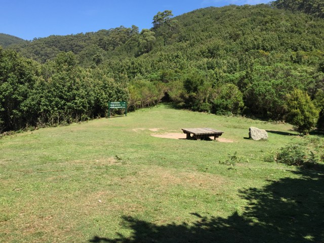
Revived we climb to windy saddle, the bridge between Mt Ramsay and Mt McAlister. It’s small grass area with a picnic table and shade tress and makes a great place for a stop and afternoon tea. From here it’s about 3 kms to the car park, or you can detour and climb to the top of Mt Ramsay, not today.
In 2011 the northern flank of Mt McAlister was deeply damaged by floods, causing a number of substantial land slides that continue to leave the landscape significantly scarred and at the time caused the closure of the Sealers Cove track, with parts impassable.
Parks and have a done great job in restoring these areas and there is a great deal of information on the trail on what the damage was what has been done to recover. The ground changes from moist and soily to dry and pebbly, with some sharp drops off and challenging switch backs if you don’t like exposed heights.


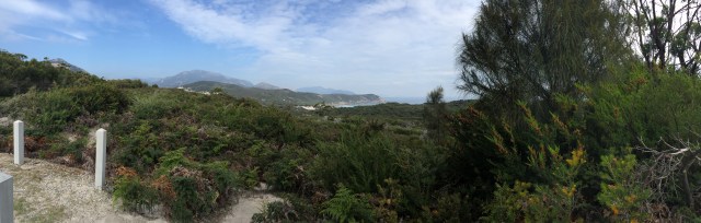
Through the worst of the damaged area it was a relief to see Mt Oberon come into view and shortly after the car park and the sign pointing the way to the Light house, loop complete!
During summer a bus runs from Ridal River to the Telegraph carpark return on weekends. If you are in private vehicle there no access to the area during that time. It’s worth being aware of this as you plan your route, no joy in an extra 3 km downhill road walk after all of this.


The oddessy over, the bucket list ticked, we make our way back home with new memories we’ll hold for a lifetime.

Pingback: Cleve Cole, snow blocks the trail | Hiking Faith